


Location Intelligence for NetSuite
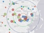
GeoBusiness for NetSuite is a Location Intelligence Platform. Real-time mapping, visualization, and geo-analytics for NetSuite. Decision-makers gain clarity from Location Intelligence whether they need to react to supply chain disruptions, forecast profits for potential locations, determine service reach and response, or coordinate sales and field service teams with optimized route planning and location tracking. Monitor operations, share data, and create actionable intelligence using Location Intelligence technology.
Key Benefits
For Sales Team Optimization: GeoBusiness STO extends NetSuite by enabling customers to interact with NetSuite records, including custom records, in a map.
- Visualize customers on a map to instantly know which areas have the most potential.
- Optimize your time by searching for nearby locations on a user friendly map interface, easily accessible from mobile devices.
- Combine your customer list and calendar into a map.
- Filter opportunities based on location and schedule.
- Find leads nearby your current or next scheduled appointment.
- Prioritize your day and quickly focus on the best opportunities for a specific location.
- Visualize your sales territories to pinpoint your best opportunities.
- Uncover underutilized leads quickly with map-based analysis.
- Identify customers by drive-time buffering. Maximize sales routes.
- Empower reps to focus, plan, and optimize their time in the field.
- Enable reps to optimize their routes for the most important prospects.
For Sales Managers and Executives: Easy-to-manage single version for the truth for your daily operations.
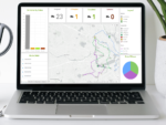
- Create operational geodashboards by adding Location Intelligence to your most critical NetSuite dashboards.
- Sales managers and executives rely on GeoBusiness to empower their sales teams by gaining insight into rep activities and performance.
- Empower sales teams to gather precisely the data you need from the field.
Field Delivery Management: GeoBusiness FDM provides a solution for companies who manage their own fleet of vehicles and drivers. GeoBusiness Field Delivery Management extends NetSuite by automating the process of creating and assigning delivery routes based on NetSuite fulfilments.
- Create/manage optimized delivery plans and driving routes for multiple truck drivers based on NetSuite fulfillments.
- Optimize daily delivery plans by ensuring the best routes for your fleet of vehicles.
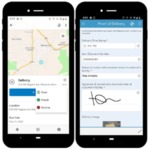
- Create custom mobile forms to collect business data related to deliveries such as Proof of Delivery, Proof of Return, bar code scanning, photos, etc.
- Use real-time geodashboards to track drivers.
- Dispatchers and truck drivers use smartphone mobile apps to manage deliver orders.
- Ensure field and office staff are using the same authoritative data.
- Deliver on your promise of products, services, and order fulfillment.
- Optimize routes based on customer location, time windows, driver breaks, and other factors.
- Manage risk by planning for natural disasters and other events.
- Respond to disruptions in real time and adjust to protect your fulfillment reputation.
- Reduce costs with smart routing and other location tools.
Field Service Management: GeoBusiness for NetSuite Field Service Management is for companies who require seamless real-time workflows between NetSuite and field service operations. GeoBusiness FSM coordinates management, field technicians, and customers in one integrated solution for NetSuite. GeoBusiness FSM is built specifically for NetSuite only. This digitally transformed approach saves money and time by eliminating duplicated efforts and wasted resources and keeping data current.
- Ensure field and office staff are using the same authoritative data.
- Customize your mobile workflows by creating data forms and checklists designed specifically for your business.
- Easily navigate through service interruptions with offline accessibility for field crews.
- Use a drag-and-drop scheduled or multi-vehicle optimized route method to schedule GeoBusiness Field Cases.
- Use real-time geodashboards to inform decisions and evaluate key performance indicator (KPI) metrics.
- Improve sustainability metrics by reducing or replacing reliance on paper.
- Add the power of mobile apps for critical functions such as data collection and route optimization.
- As technicians collect information from iOS and Android compatible smartphone apps, field data is updated in NetSuite in real-time.
- Automated multi-vehicle optimized route scheduling. Given a set of GeoBusiness Field Case locations and a fleet of vehicles, use the GeoBusiness routing service to determine what stops should be serviced by each route and in what sequence.
- View progress of assignments in real-time from the backoffice via map-centric operational geodashboards.
For Real-Time Location Tracking: With so many people and things in motion, business and government leaders don’t have time to manually track each movement. With location intelligence, they can create live maps and apps for monitoring. By seeing what’s happening now and analyzing what has already happened, decision-makers can identify opportunities for growth, safety, and efficiency.
- Monitor operations, resources, and assets—from field crews to vehicle fleets—using live maps, apps, and dashboards.
- Analyze and display real-time data from sensors, devices, and social media feeds.
- Put live tracking data in context of road or utility networks, hazards, weather, and demographics.
- Send commands to sensors when patterns of interest are detected.
- Get real-time alerts and visualization on maps and dashboards.
- Integrate location history data with infrastructure data to discover trends and outliers.
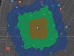
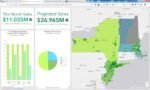
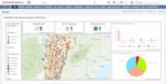
For Site Analysis and Territory Planning: Competing with both brick-and-mortar neighbors and online retailers, today’s businesses can’t afford to choose a bad location. Innovative business leaders use location intelligence to forecast profits for potential locations and networks of locations and to make strong site selection and market planning decisions.
Smart maps show current store performance or customer base in context of location and market opportunity. Spatial analysis enables selection of the most profitable sites based on competition, demographics, and supply chain.
- Design and realign territories from the ground up based on capacity, account priority, rep assignment, or geography to ensure the right field sales reps are in the right place, at the right time.
- Identify and target the most profitable locations.
- Make repeatable growth decisions at scale.
- Avoid cannibalizing sales and jeopardizing current business.
- Optimize online buying and in-store customer engagement.
- Make the most of store, market, and merchandise mixes.
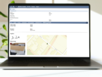
For Customer Service: Businesses need to connect customers with the correct team members or partners for service and support. Location centric workflows and tools show what, where, and why. Go beyond gut instinct or guesswork to connect and optimize customer experiences.
- A map-based visualization of all your customer, partner, and other NetSuite data.
- Multi-objective, multi-day routes go beyond point-to-point consumer routing software.
- Find closest vendors and service centers based on location searches.
- Capture survey data related to customers anytime, anywhere on smart devices, laptops, or desktops as a native app and also in the browser.
For Market and Customer Analysis: Businesses have more customer data than ever but struggle to make sense of it. Location-enriched data shows what, where, and why customers buy. Business leaders and marketers can go beyond gut instinct or guesswork to find potential customers, identify target markets, advertise strategically, and plan product mixes.
Location is the key to unlocking rich customer data for precise market analysis and strategic business decisions.
- Reduce ambiguity when entering new markets and optimize market planning decision-making.
- Gain insight into the values and habits that shape customer behavior.
- Create data-driven, personalized shopping experiences that increase customer loyalty.
- Leverage smart maps and visualizations that uncover patterns in key data such as drive times, population densities, demographics, and psychographics.
- Better understand the demographic makeup of the areas around your locations, identify new sites, discover where your competitors are, and so much more.
- Combine demographic, lifestyle, and spending data with map-based analytics for accurate reports and dynamic presentations.
- Visualize your current and potential sites, consumer patterns, trends, concentrations of customers, and event traffic patterns around a specific location.
Potential Industry use examples include Franchise Acquisition, Healthcare, Retail, Urban Planning, Restaurants and Hospitality, Economic Development, Transportation and Logistics, Product Merchandising and Advertising, Food and Beverage, Occupational Safety, Higher Education Recruiting, Real Estate Development, Wholesale Distribution.
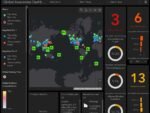
For Supply Chain Digitization: Manufacturers move high volumes in a dynamic and risky global environment. To be agile, all stakeholders must know what is happening and where—in real time. Supply chain digitization combines live business and location data in a single geodashboard, giving leaders a new level of end-to-end operational awareness and analysis. By seeing the whole picture, supply chain operators can improve efficiency, prevent disruption, and gain competitive advantage.
Supply chain digitization with location technology delivers valuable insights—such as real-time status, service area gaps, and opportunities.
- Understand all network connections, suppliers, inventory levels, complex relationships, and potential impacts.
- Identify opportunities to boost performance, be more agile, and optimize connections to customers or suppliers.
- Gain visibility to ensure ethical and sustainable supply sources.
- Access and analyze Internet of Things (IoT) data for continuous improvement.
- Receive alerts when disruptions occur or service-level agreements are at risk.
For Facility Management: To manage and maintain any facility—its safety, security, and operations—is a complex and expensive effort. Facility managers achieve success using powerful data management, analysis, and visualization. A digital approach to facility management helps leaders assess security risks, develop plans, protect staff and assets, and improve daily operations.
Smart maps help facility managers understand their spaces and the people in them and oversee daily operations.
- Get real-time operational awareness of campus spaces, asset inventories, and building conditions.
- Improve wayfinding with indoor mapping.
- See the locations of service requests or emergency alerts in real time.
- Create map-driven floor plans for work spaces that minimize distractions and maximize teamwork.
- Gain insight into movement patterns through visualization and discover ways to cut costs, protect assets, and increase safety.
- Simplify coordination of construction, renovation, and maintenance projects.
For Logistics and Fulfillment: In logistics management, being on time and meeting customer expectations is everything. Dispatchers need to prepare for any threat to delivery operations—from contamination to natural disasters to theft. Easy-to-understand digital geodashboards that fuse location intelligence and all operational data provide real-time insights. Adjustments can be made in the moment, and delays minimized to stay on schedule.
- The world’s largest delivery companies use location intelligence to optimize routes, arrive when projected, and meet high customer service expectations.
- Deliver on your promise of products, services, and order fulfillment.
- Optimize routes based on customer location, time windows, cargo transfers, and other factors.
- Manage risk by planning for natural disasters and other events.
- Respond to disruptions in real time and adjust to protect your fulfillment reputation.
- Reduce costs with smart routing and other location tools.
For Asset Tracking and Analysis: Asset managers must minimize risks and maximize performance while managing cost and resources for both fixed and moving assets. Innovative managers use smart maps and dashboards to achieve a holistic view of their assets. Location intelligence enhances day-to-day operations such as inspections, maintenance, and investment planning.
When managers use smart maps and visualizations to perform asset tracking and analysis, they help their organizations reduce errors; save time; and make informed, data-driven decisions.
- Increase inventory accuracy by using modern data collection apps.
- Track asset condition and performance in real time throughout the life cycle.
- Share status updates quickly and seamlessly with the field and office.
- Forecast maintenance costs and needs to improve reliability.
- Manage customer expectations.
- Integrate fully into existing asset management systems and inventory tracking.
For Situational Awareness: In the complex realm of business operations or large-scale events, it’s difficult to know what is happening where. Using location intelligence, business leaders and first responders see a holistic view of the situation—real-time data such as weather and traffic, on-the-ground updates, plus the locations of assets, crews, and other resources. This approach leads to smart decisions in the moment and predictive abilities for the future.
Decision-makers gain clarity from location intelligence whether they need to react to supply chain disruptions, repair damage to a utility network, or coordinate first responders in an emergency.
- Monitor resources and operations in real time.
- Integrate data from multiple sources including Internet of Things (IoT) and social media feeds.
- Visualize and share all key information with one map view.
- Perform quick spatial analysis of an impending event.
- Create an informed incident response plan in minutes.
For Performance Monitoring: Work at peak levels. Business leaders are under increasing pressure to be more efficient and transparent. Innovative leaders use location intelligence to monitor, manage, and analyze key performance indicators. This real-time view of how assets and operations are performing helps identify inefficiencies and makes it easier to share data.
A shared map view of performance empowered by real-time analytics leads to greater efficiencies and collaborative problem solving.
- Harness smart maps, analytics, and dashboards for a real-time view of operations, people, services, assets, and events.
- Identify areas of improvement by viewing key performance indicators in context of location.
- Collaborate and share data effectively and securely via maps, apps, and dashboards.
- Strengthen quality control in business processes.
- Improve response time to problems and issues.
For Risk Management: Business leaders face unprecedented risk from disasters, geopolitical shifts, and security threats. They can use location intelligence to visualize risk on smart maps, find patterns and trends in big data, and communicate seamlessly during risk mitigation and response. This modern approach to risk management saves time, money, and lives.
Smart maps pinpoint areas of potential risk, reveal deeper insights on how to manage risk, and provide a common view that streamlines communication during all phases of risk management.
- Know where to allocate resources with data-driven risk assessment.
- Use predictive analytics to reveal patterns and trends.
- Share real-time data to understand impacted assets, people, and places.
NetSuite and Enterprise Geospatial Integration
GeoBusiness connects NetSuite to Esri’s pioneering ArcGIS technology, the world’s most powerful mapping and analytics software.
Esri, the global market leader in geographic information systems (GIS), offers the most powerful mapping and spatial analytics technology available. Since 1969, Esri has helped customers unlock the full potential of geospatial data to improve operational and business results. Today, Esri software is deployed in more than 350,000 organizations including the world’s largest cities, national governments, 75% of the Fortune 500, and more than 7,000 colleges and universities. Esri engineers the most advanced solutions for digital transformation, IoT, and location analytics to create the maps that run the world.
GeoBusiness mapping and analytics inspires positive change across industries: architecture, engineering, construction, financial services, healthcare, insurance, manufacturing, wholesale distribution, natural resources, petroleum & pipeline, real estate, retail, sustainable energy development, restaurants & Hospitality, Food & Beverage, Health & Beauty, Apparel, Footwear & Accessories, Transportation & Logistics.
If you have an existing GIS, build on the investment you’ve made in maturing your Enterprise by seamlessly integrating with NetSuite. Unlock the ability to connect spatial locations and attributes of assets and other business data from ArcGIS and NetSuite in real time.